© TruGIS
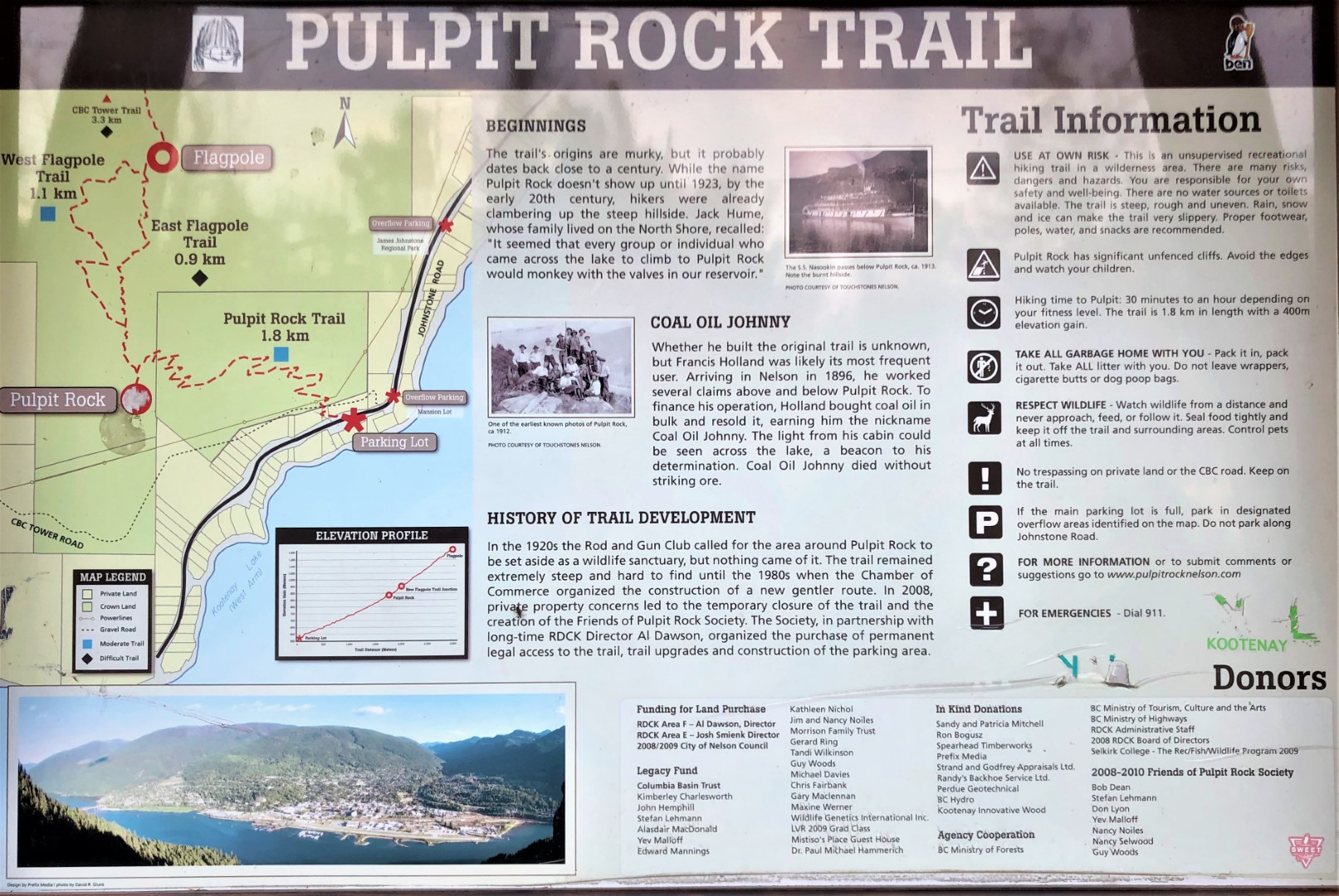
Pulpit Rock is easily the most popular trail in Nelson. With lots of switch-backs, the trail provides a good work-out before it ends on top of Pulpit Rock with a big view over town. Learn more on West Kootenay Hiking.
Difficulty: Easy
Distance: 3.76km (round trip)
Avg Grade: 18.2%
Lowest Elevation: 556m
Highest Elevation: 898m
Elevation Gain: 342m
An extension of the Pulpit Rock Trail, the Flagpole Trail network can be hiked as a loop with a difficult or moderate route to the top. This trail provides big views west over the Kootenay River Valley. The wildflowers are great in May! Learn more on West Kootenay Hiking.
Difficulty: Moderate
Distance: 7.18 km (round trip)
Avg Grade: 25.1%
Lowest Elevation: 556m
Highest Elevation: 1,231m
Elevation Gain: 675m
Going even further from the Flagpole Trail, you can hike all the way to the top of Elephant Mountain on the CBC Tower Trail. This is a challenging hike and takes 6-8 hours. Learn more on West Kootenay Hiking.
Difficulty: Difficult
Trailhead: Pulpit Rock Trailhead or Lyon’s Bluff Trailhead
Distance: 11.9km
Lowest Elevation: 560m
Highest Elevation: 1,686m
Elevation Gain: 1,126m
Follow Highway 3A across the Big Orange Bridge and then turn onto Johnstone Road. Reach the trailhead 3km down the road. There is an overflow parking area.
Warm weather – As the temperature increases, additional hydration supplies are recommended to reduce the risks associated with dehydration and heat exhaustion. Please remember to take all containers and packaging home with you. Appropriate protection from the sun to prevent sunburn, including sunscreen and a brimmed hat, may also be required.
Rainfall/water – Rainfall and water on the trail increases the risk of slips, falls and injuries due to reduced tractions and loosening of trail materials. Be especially carefully when stepping onto rocks covered with moisture. Appropriate footwear and hiking poles may reduce some of the risk.
Cold weather – Cold weather requires appropriate clothing and footwear to stay warm and to reduce the risk of hypothermia or frostbite. Snow, slush, hail or ice present on the trail can lead to additional risks as outlined below.
Snow/Slush/Hail – Snow, slush and hail can conceal hazards (rocks, ice, holes, etc) and cause the trail to be very slippery or suddenly give way. Deep snow can also require more physical efforts to move through and lead to exhaustion. Appropriate training, footwear, traction devices and hiking poles are recommended for those who choose to proceed.
Ice – Ice, whether visible or hidden under snow, slush, hail, soil, vegetation or other covering, can be extremely slippery and is an especially treacherous hazard on all sections of the Pulpit Rock trail. Descents require extreme caution – remember if you have difficulty going up, it is much more difficult coming down. Appropriate training, footwear, traction decives and balance devices (e.g., poles) are strongly recommended for those who choose to proceed in icy conditions.
Darkness/Nightfall – Hiking after nightfall and in dark conditions is not recommended due to increased risks of injury. Please allow for plenty of time to complete your hike prior to nightfall. If hiking in the afternoon, be prepared by bringing along a headlamp or flashlight.
Storms/Wind/Lightning – the probability of falling branches or trees striking hikers increases greatly during storms, strong winds and lightning activity. Storms and winds can also cause a loss of balance. Lightning strikes can be fatal. Cold weather often accompanies storms and strong winds.
© TruGIS